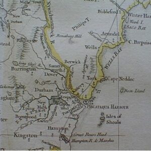
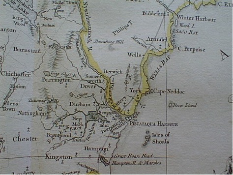
A forgotten 1761 map, prepared for George III’s war minister, shows that New Hampshire once owned all of the Portsmouth Harbor. The map could help inform the New Hampshire Senate when it takes up HR 45, reasserting New Hampshire’s control over key harbor islands, in 2026.
Since 1997, Maine has controlled half of Portsmouth Harbor, including Seavey’s Island, site of the Portsmouth Naval Shipyard, and Badger’s Island—the island depicted on New Hampshire’s state flag. That year, Maine began garnishing the pay of Granite Staters working at the shipyard, claiming it was collecting unpaid “back taxes” on their income.
As Maine was launching this land grab, then-Governor Jeanne Shaheen was on a trade mission to England—where she happened to visit an archive of colonial records. Unfamiliar with the history of the harbor, Shaheen was startled to find maps depicting the entire harbor as New Hampshire territory. This discovery prompted her to instruct the state Department of Justice to pursue legal action against Maine.
New Hampshire’s lawsuit produced a famous 2001 US Supreme Court case, New Hampshire v. Maine. This case is often mischaracterized in media reports, which sometimes say the Court “declared that the shipyard is part of Maine.” In reality, the Supreme Court only blocked New Hampshire from “asserting that the Piscataqua [harbor] boundary runs along the Maine shore.” The Supreme Court never directly addressed the status of the harbor islands or even blocked New Hampshire from claiming them. So is the Naval Shipyard part of New Hampshire or Maine?
Most historical maps of the harbor are not readily available online. While the New York Times has an online record of Shaheen’s visit to England, it does not include actual pictures of any maps or tell us exactly what maps Shaheen saw. To better understand the boundary dispute, I contacted the Hampshire Record Office in Winchester, England to track down the map.
Governor Shaheen viewed an official Crown map prepared for Charles Townshend, George III’s Secretary at War, in 1761. Though the copy Shaheen saw now sits in a private collection, the Hampshire Record Office retained a photograph of the map from Governor Shaheen’s 1997 visit, which I purchased from the archive. It has never before been published online.
The map shows the borders of the District of Maine, then part of Massachusetts Bay Colony, beginning north of the Portsmouth Harbor on the Maine shore. This shows that the harbor islands, including Seavey’s Island, were part of the Colony of New Hampshire.
Multiple versions of this 1761 map have survived—each revealing the harbor boundary in complementary ways. A second version of Townshend’s map can be found in the MacLean Collection Map Library. While the copy Shaheen discovered uses yellow edging to show the borders of the District of Maine, the MacLean version has a visible dotted line marking all of New Hampshire’s interstate boundaries. The harbor boundary is shown running along the Maine shore—corroborating New Hampshire’s ownership of the harbor.
A forgotten 1761 map, prepared for the Privy Council of George III, shows the legal borders of the District of Maine did not include any part of Portsmouth Harbor.
This evidence lines up with the historical record. New Hampshire de facto controlled the entire harbor from 1679, when King Charles II first recognized New Hampshire as a colony, until the mid-20th century. During the American Revolution, the Granite State built Fort Sullivan on Seavey’s Island—named for John Sullivan, commander of our revolutionary forces and third governor—and used the fort to control ship traffic until the federal government took over most harbor controls in 1896. While New Hampshire no longer quarantined ships in the 20th century, it continued to exercise other harbor responsibilities—such as unilaterally paying for whole-harbor renovations—even after the territorial dispute with Maine first erupted in the 1970s.
Badger’s Island, shown on the New Hampshire flag and state seal, was the site of a shipyard owned by John Langdon, our second governor and a signatory of the US Constitution—and was used to build the USS Raleigh and later John Paul Jones’ USS Ranger.
In the January edition of the New Hampshire Bar News, I will be publishing other forgotten historical maps uncovered in the archives of the Massachusetts Historical Society and Portsmouth Athenaeum—all supporting New Hampshire’s historic claims.
A renewed understanding of these historical maps could help inform our state legislature in addressing duty station assignments, the statutory borders of Rockingham County, the scope of New Hampshire’s law enforcement prerogatives, and the potential to direct the state Department of Justice to relitigate the harbor boundary dispute.
In 2025, the New Hampshire House passed HCR 8, sponsored by Rep. Joseph Barton. The resolution would ask President Trump to change the official duty stations of Naval Shipyard employees from Maine to New Hampshire. This would free Granite State shipyard workers from Maine income taxes and revive New Hampshire’s historic claim to the harbor. Unfortunately, the New Hampshire Senate did not act on the resolution.
This year, Rep. Barton has reintroduced the resolution as HR 45. This time, Granite Staters should call on the Senate to pass HR 45 and reclaim New Hampshire’s historic right to Seavey’s and Badger’s Islands.